Temporali Lunedì 12?
Moderatori: Moderatore, TheSoundOfWind

Re: Temporali Lunedì 12?
secondo lamma ecmwf 12z no el fa en casso 
Buona l'acqua del pozzo.
Grazie Gino. Mai nessuno come te. Sarai SEMPRE il MIO Presidente.
Grazie Gino. Mai nessuno come te. Sarai SEMPRE il MIO Presidente.

Re: Temporali Lunedì 12?
marco71 ha scritto:Ci sono novità dell'ultimora ?
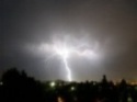
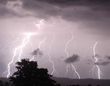
Io per la Pianura la vedo dura oggi, qualche temporale su Alpi e Prealpi dovrebbe farlo, sentiamo i più esperti però...
-
Liriometeo

- Socio fondatore
- Messaggi: 37514
- Iscritto il: ven 29 feb, 2008 21:06
- Località: cologne franciacorta ( Brescia) , riccione ( Rn )
- Contatta:
Re: Temporali Lunedì 12?
Cosmo poco fa


Ultima modifica di Liriometeo il dom 11 mag, 2014 09:43, modificato 2 volte in totale.
Re: Temporali Lunedì 12?
Cosmo non vede più nulla in Pianura, le correnti sono sparate e non favorevoli alla Pianura, vediamo.. 
Re: Temporali Lunedì 12?
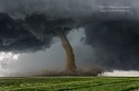
Appero' ESTOFEX....
... Northern Italy ...A potentially dangerous setup is evolving over this region. Surface observations reveal dewpoints around 14 °C with backing low-level flow due to the falling surface pressure. With short-wave trough approaching region, steep mid-level lapse rates will overlay rather moist boundary layer, resulting in low to moderate CAPE values. Intense vertical wind shear is forecast, with DLS values 30 to 45 m/s. Although hodographs should be mostly straight, easterly to southeasterly surface winds ahead of the surface low will result in enhanced SREH with around 150 m2/s2 in the 0-3 km layer. As such, conditions will be prime for supercells with threats of large to very large hail and damaging wind gusts. Tornadoes might occur as well as well due to very strong vertical wind shear although cloud bases could be quite high in the early afternoon - therefore tornado threat will be most prominent towards the evening.
... Northern Italy ...A potentially dangerous setup is evolving over this region. Surface observations reveal dewpoints around 14 °C with backing low-level flow due to the falling surface pressure. With short-wave trough approaching region, steep mid-level lapse rates will overlay rather moist boundary layer, resulting in low to moderate CAPE values. Intense vertical wind shear is forecast, with DLS values 30 to 45 m/s. Although hodographs should be mostly straight, easterly to southeasterly surface winds ahead of the surface low will result in enhanced SREH with around 150 m2/s2 in the 0-3 km layer. As such, conditions will be prime for supercells with threats of large to very large hail and damaging wind gusts. Tornadoes might occur as well as well due to very strong vertical wind shear although cloud bases could be quite high in the early afternoon - therefore tornado threat will be most prominent towards the evening.
-
MauriTs
- Temporale con neve

- Messaggi: 3377
- Iscritto il: ven 01 apr, 2011 13:53
- Località: Bagnolo Mella (BS)
- Contatta:
Re: Temporali Lunedì 12?
Radu ha scritto:Appero' ESTOFEX....
... Northern Italy ...A potentially dangerous setup is evolving over this region. Surface observations reveal dewpoints around 14 °C with backing low-level flow due to the falling surface pressure. With short-wave trough approaching region, steep mid-level lapse rates will overlay rather moist boundary layer, resulting in low to moderate CAPE values. Intense vertical wind shear is forecast, with DLS values 30 to 45 m/s. Although hodographs should be mostly straight, easterly to southeasterly surface winds ahead of the surface low will result in enhanced SREH with around 150 m2/s2 in the 0-3 km layer. As such, conditions will be prime for supercells with threats of large to very large hail and damaging wind gusts. Tornadoes might occur as well as well due to very strong vertical wind shear although cloud bases could be quite high in the early afternoon - therefore tornado threat will be most prominent towards the evening.
Io non so, a guardare le mappe sono scettico per la pianura per diversi fattori, se però guardo il cielo è buono con la prima cumulogenesi in atto.. mi sa che si dovrà andare di nowcasting

Severe Weather Photography.
Re: Temporali Lunedì 12?
Maurithestorm ha scritto:Radu ha scritto:Appero' ESTOFEX....
... Northern Italy ...A potentially dangerous setup is evolving over this region. Surface observations reveal dewpoints around 14 °C with backing low-level flow due to the falling surface pressure. With short-wave trough approaching region, steep mid-level lapse rates will overlay rather moist boundary layer, resulting in low to moderate CAPE values. Intense vertical wind shear is forecast, with DLS values 30 to 45 m/s. Although hodographs should be mostly straight, easterly to southeasterly surface winds ahead of the surface low will result in enhanced SREH with around 150 m2/s2 in the 0-3 km layer. As such, conditions will be prime for supercells with threats of large to very large hail and damaging wind gusts. Tornadoes might occur as well as well due to very strong vertical wind shear although cloud bases could be quite high in the early afternoon - therefore tornado threat will be most prominent towards the evening.
Io non so, a guardare le mappe sono scettico per la pianura per diversi fattori, se però guardo il cielo è buono con la prima cumulogenesi in atto.. mi sa che si dovrà andare di nowcasting
Sicuramente non ci sarà un passaggio diffuso,anzi...la maggior parte delle aree rimarrà all'asciutto,come d'altra parte vedono i lam.
Tuttavia è una di quelle occasioni in cui può partire qualche cella isolata ma cattiva;a livello di pianura sicuramente favorito il triveneto,qui da noi vedo in pole la pedemontana specie verso il Garda,possibilità più basse ma non nulle sul resto della provincia.
-
simone
- Direttivo Meteopassione
- Messaggi: 13043
- Iscritto il: sab 01 mar, 2008 09:18
- Località: palazzolo sull'oglio
Re: Temporali Lunedì 12?
Secondo me questo e stato uno dei casi in cui l'ingresso da dry linea ha di fatto sfaldato i sistemi temporaleschi. mi aspettavo qualcosa di meglio ma l'innesco della linea ha coinciso con lo sfaldamento della linea temporalesca in azione sulle prealpi.come pensavo si e formata nella pianura una seconda linea temporalesca causata dalla convergenza dry line e venti da sudovest.mi e sembrato di vedere sia stata attiva soprattutto dal mantovano verso est...